
Camino Vasco del Interior
The Camino Vasco del Interior (Basque Inland Way), or Camino del Interior, enters Spain at Irún and crosses Gipuzkoa and Álava via Tolosa, the San Adrián tunnel and Vitoria-Gasteiz to join the Camino Francés. From La Puebla de Arganzón it has two endings: via Haro to Santo Domingo de la Calzada, 199.9 km from Irún, or via Miranda de Ebro and Briviesca to Burgos, 257.2 km.
It is part of the Northern Routes declared a World Heritage Site by UNESCO in 2015. It is a route of green valleys, towns with palaces and a great mountain crossing over the Sierra de Aizkorri, followed by the Álava plain and the uplands of La Bureba, with very few pilgrims. In this guide to the Camino Vasco del Interior you have the key facts, the stages by section, a summary of each stage, the profile, the history, the must-see places, when to go, how to get to Irún, where to sleep, what to eat and which variant to choose.
- The stages
- Key facts
- Stages by section
- Stage by stage
- The profile
- Via Haro or via Burgos?
- History
- Must-sees
- When to go
- Getting there
- Where to sleep
- What to eat
- Tips
- Credential and Compostela
- FAQ
The stages of the Camino Vasco del Interior
The map shows the whole route and below it each stage with its start, finish and distance. Tap one to see its elevation profile, the villages along the way and where to sleep.
Easy Moderate Hard
Camino Vasco del Interior key facts
| Fact | Basque Interior Way |
|---|---|
| Common section | Irún › La Puebla de Arganzón: 148.6 km in 6 stages |
| Via Haro | La Puebla › Santo Domingo de la Calzada: 51.3 km in 2 stages; 199.9 km from Irún |
| Via Miranda de Ebro | La Puebla › Burgos: 108.6 km in 5 stages; 257.2 km from Irún |
| To Santiago | About 740 km from Irún via Burgos |
| Total ascent | About 3,500 m to Burgos |
| Highest point | 1,143 m, in the Sierra de Aizkorri, next to the San Adrián tunnel |
| Albergues | 27 (18 public); 20 open all year |
| Albergue bed | €15.40 on average |
| Asphalt or paved | 57% of the route |
| Longest section without a fountain, bar or shop | 17.7 km, on the way into Burgos |
| Backpack transfer with Correos | No Correos service on this route |
The stages of the Camino Vasco del Interior by section
The Camino Vasco del Interior climbs from the bay of Txingudi up the Oria and Goierri valleys, crosses the Cantabrian watershed through the San Adrián tunnel, crosses the Llanada Alavesa to Vitoria and descends to La Puebla de Arganzón, where the two variants split.
Gipuzkoa, from Irún to Zegama: 3 stages and 79.1 km
The first stage, 24.4 km, climbs and drops through the Oiartzun valley and the Santiagomendi hill to Astigarraga and Hernani, with about 780 m of climbing. The second, from Hernani to Tolosa, is almost flat along the Oria valley, Urnieta, Andoain and Anoeta. The third is long, 35.2 km from Tolosa to Zegama via Alegia, Legorreta, Ordizia, Beasain, Idiazabal and Segura: it can be split at Beasain, 18.6 km from Tolosa. See the stage Tolosa › Zegama.
Álava, San Adrián and the Llanada: 3 stages and 69.5 km
The queen stage leaves Zegama and climbs about 880 m to the San Adrián tunnel, a natural cave that goes through the sierra, and continues along the medieval road to the highest point of the route, at 1,143 m, before descending to Zalduondo and Salvatierra/Agurain: 22.8 km. Then 27.9 almost flat km across the Llanada Alavesa and Alegría to Vitoria-Gasteiz, and 18.8 km via Armentia and the Vitoria hills to La Puebla de Arganzón. See the stage Zegama › Salvatierra.
Variant via Haro to Santo Domingo: 2 stages and 51.3 km
From La Puebla de Arganzón to Haro, 30.7 km with about 580 m of climbing via Salinillas de Buradón, in the Rioja Alavesa, and from Haro to Santo Domingo de la Calzada, 20.6 km among vineyards, where it joins the Francés. It is the shortest variant to reach the Francés and passes through the capital of Rioja wine. See the stage La Puebla de Arganzón › Haro.
Variant via Miranda de Ebro to Burgos: 5 stages and 108.6 km
From La Puebla you go down to Miranda de Ebro, 21.2 km via Burgueta, Estavillo, Armiñón and Bayas. Then the Pancorbo gorge, 16.5 km; the fields of La Bureba to Briviesca, 23.3 km with an 11 km stretch without services; Monasterio de Rodilla, 19.2 km, much of it next to the road, and the arrival in Burgos, 28.4 km with 17.7 km without a fountain or bar. See the stage Miranda de Ebro › Pancorbo.
The Camino Vasco del Interior stage by stage
A summary of each stage of the Camino Vasco del Interior: distance, climbing, villages on the way and where there is accommodation. Each stage page has the map, the profile and all the services.
Stage 1: Irún › Hernani. 24.4 km and about 780 m of climbing; moderate. It passes through Gurutze, Elizalde, Iturriotz, Santiagomendi and Astigarraga. Before the end there is accommodation in Gurutze (2), Elizalde (2), Santiagomendi (1) and Astigarraga (4), in case you want to shorten it. See the stage.
Stage 2: Hernani › Tolosa. 19.5 km and about 190 m of climbing; easy. It passes through Urnieta, Andoain, Elbarrena and Anoeta. Before the end there is accommodation in Urnieta (6), Andoain (2) and Anoeta (1), in case you want to shorten it. See the stage.
Stage 3: Tolosa › Zegama. 35.2 km and about 590 m of climbing; hard. It passes through Alegia, Ikaztegieta, Legorreta, Itsasondo, Ordizia and Beasain. Before the end there is accommodation in Alegia (1), Legorreta (1), Itsasondo (1) and Ordizia (1), in case you want to shorten it. See the stage.
Stage 4: Zegama › Salvatierra. 22.8 km and about 880 m of climbing; hard. It passes through the San Adrián tunnel, Zalduondo and Mezkia. Before the end there is accommodation in Zalduondo (3), in case you want to shorten it. See the stage.
Stage 5: Salvatierra › Vitoria-Gasteiz. 27.9 km and about 90 m of climbing; moderate. It passes through Gazeo, Ezkerekotxa, Alegría/Dulantzi, Elburgo/Burgelu, Villafranca de Estíbaliz and Argandoña. Before the end there is accommodation in Alegría/Dulantzi (1), in case you want to shorten it. See the stage.
Stage 6: Vitoria-Gasteiz › La Puebla de Arganzón. 18.8 km and about 250 m of climbing; easy. It passes through Armentia, Gometxa and Subijana de Álava / Subillana-Gasteiz. Before the end there is accommodation in Armentia (1), in case you want to shorten it. See the stage.
Stage 7: La Puebla de Arganzón › Haro. 30.7 km and about 580 m of climbing; hard. It passes through Burgueta, Estavillo, Berantevilla, Zambrana, Salinillas de Buradón and Briñas. Before the end there is accommodation in Estavillo (1), Salinillas de Buradón (1) and Briñas (4), in case you want to shorten it. See the stage.
Stage 8: Haro › Santo Domingo de la Calzada. 20.6 km and about 200 m of climbing; moderate. It passes through Zarratón and Bañares. Before the end there is accommodation in Zarratón (1), in case you want to shorten it. See the stage.
Stage 9: Miranda de Ebro › Pancorbo. 16.5 km and about 190 m of climbing; easy. It passes through Orón and Ameyugo. See the stage.
Stage 10: Pancorbo › Briviesca. 23.3 km and about 280 m of climbing; easy. It passes through Zuñeda, Grisaleña and Cameno. See the stage.
Stage 11: Briviesca › Monasterio de Rodilla. 19.2 km and about 150 m of climbing; easy. It passes through Prádanos de Bureba, Castil de Peones, Revillagodos, Quintanavides and Santa Olalla de Bureba. Before the end there is accommodation in Quintanavides (1), in case you want to shorten it. See the stage.
Stage 12: Monasterio de Rodilla › Burgos. 28.4 km and about 180 m of climbing; easy. It passes through Villímar. Before the end there is accommodation in Villímar (1), in case you want to shorten it. See the stage.
The Camino Vasco del Interior profile
The Basque part is the demanding one: it climbs and drops over hills and valleys in Gipuzkoa and gains more than 800 m on the climb to San Adrián. From Salvatierra the route runs across the Meseta, between about 450 and 1,000 m of altitude, with little climbing but long stages and villages further apart.
| Stage | From › to | Km | Ascent | Max. altitude | Difficulty |
|---|---|---|---|---|---|
| 1 | Irún › Hernani | 24.4 | 780 m | 300 m | Moderate |
| 2 | Hernani › Tolosa | 19.5 | 190 m | 106 m | Easy |
| 3 | Tolosa › Zegama | 35.2 | 590 m | 343 m | Hard |
| 4 | Zegama › Salvatierra | 22.8 | 880 m | 1,143 m | Hard |
| 5 | Salvatierra › Vitoria-Gasteiz | 27.9 | 90 m | 616 m | Moderate |
| 6 | Vitoria-Gasteiz › La Puebla de Arganzón | 18.8 | 250 m | 749 m | Easy |
| 7 | La Puebla de Arganzón › Haro | 30.7 | 580 m | 683 m | Hard |
| 8 | Haro › Santo Domingo de la Calzada | 20.6 | 200 m | 644 m | Moderate |
| 9 | Miranda de Ebro › Pancorbo | 16.5 | 190 m | 639 m | Easy |
| 10 | Pancorbo › Briviesca | 23.3 | 280 m | 800 m | Moderate |
| 11 | Briviesca › Monasterio de Rodilla | 19.2 | 150 m | 852 m | Easy |
| 12 | Monasterio de Rodilla › Burgos | 28.4 | 180 m | 1,012 m | Moderate |
The stage from La Puebla de Arganzón to Miranda de Ebro, 21.2 km and 179 m of climbing, is almost flat. The climbing and altitude of each stage are calculated from the route track and are approximate.
Via Haro or via Burgos?
The variant via Haro is the shortest: you reach the Francés at Santo Domingo de la Calzada after 199.9 km and 8 stages from Irún, and pass the wine cellars of Haro. The variant via Miranda de Ebro is longer, 257.2 km and 11 stages to Burgos, lonelier and with fewer services, but it joins the Francés in one of its great cities and saves you the stages from Santo Domingo to Burgos, about 70 km over the Montes de Oca. If you have time and want more Camino, choose Haro and continue along the Francés; if you prefer solitude and Meseta, choose Burgos.
History of the Camino Vasco del Interior
The Camino del Interior leads from Irún to the Meseta without following the coast, and its great crossing is the San Adrián tunnel, a natural cave in the Sierra de Aizkorri through which the road between the Llanada Alavesa and Gipuzkoa passed. For centuries it was one of the main routes between the Meseta and Europe, used by merchants, armies, kings and pilgrims, and a small chapel survives inside the cave.
In 2015 UNESCO extended the World Heritage listing of the Camino de Santiago to the Northern Routes: the Coastal Way, the Primitivo, the Lebaniego and this Inland Way of the Basque Country and La Rioja.
Must-sees on the Camino Vasco del Interior
The places worth a stop, in the order they appear on the Camino Vasco del Interior.
- Church of El Juncal · Irún (stage 1). A large 16th-century church, Gothic in structure with a Baroque doorway, on Calle de Santiago; nearby, the Baroque town hall on Plaza de San Juan.
- Historic centre · Tolosa (stage 2). The church of Santa María, with its apse on the old town wall by the river; the palaces of Idiakez, Aranburu and Atodo, the Tinglado market and the Puerta de Castilla, through which the Camino leaves.
- Igartza complex · Beasain (stage 3). A 13th-century defensive tower turned in the 16th century into a manor house with an ironworks, mills, wine press, chapel and bridge, all in stone and wood.
- Church of San Martín de Tours · Zegama (stage 3). A 15th to 18th-century church with the mausoleum of General Zumalacárregui, who died here in 1835, and a Renaissance altarpiece.
- San Adrián tunnel · Sierra de Aizkorri (stage 4). The natural cave through which the Camino crosses the sierra, with a chapel inside and the cobbled medieval road on the other side.
- Fortified churches · Salvatierra/Agurain (stage 4). Santa María and San Juan, one at each end of Calle Mayor, among arcaded squares and 16th and 17th-century manor houses.
- Chapel of Nuestra Señora de Ayala · Alegría/Dulantzi (stage 5). A 13th-century chapel, almost on the path, one of the most interesting examples of Basque Romanesque.
- Cathedral of Santa María · Vitoria-Gasteiz (stage 5). A Gothic cathedral at the top of the old town that can be visited during restoration, with a guide: foundations, crypt, triforium, tower and a portico that keeps its colouring; there is a discount with the credencial.
- Salinillas de Buradón · Salinillas de Buradón (stage 7). A walled village and listed monumental ensemble, with the 15th-century hospital of Santa Ana, the church of La Inmaculada and the palace of the Counts of Oñate.
- Cathedral of Santo Domingo · Santo Domingo de la Calzada (stage 8). A cathedral of Romanesque origin with the saint’s mausoleum and its free-standing 18th-century tower, 69 m tall.
- Church of El Espíritu Santo and Carlos III bridge · Miranda de Ebro (stage 9). A church with a Romanesque doorway and apse in the Allende district and, over the Ebro, the 1777 ashlar bridge leading to the old town.
- Santa Clara altarpiece · Briviesca (stage 10). An impressive unpainted walnut altarpiece, 24 m high, in the church of the convent of Santa Clara; visits are booked at the tourist office.
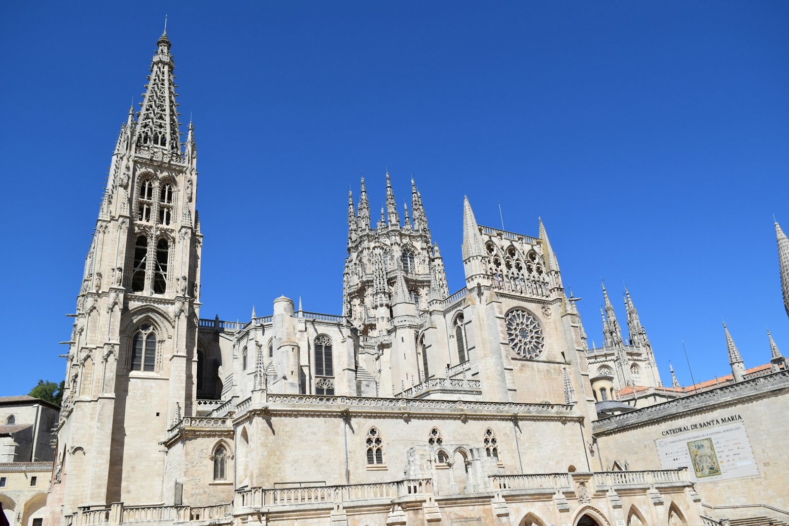
- Burgos Cathedral · Burgos (stage 12). A Gothic cathedral begun in 1221 and a World Heritage Site since 1984, with its towers, the Sarmental doorway, the Golden Staircase and the Constable’s Chapel.
When to walk the Camino Vasco del Interior
The best seasons are May to June and September to October. In winter there may be snow at San Adrián and the Meseta is cold (the route’s average lows drop to 2.2 °C in January); 20 of the 27 albergues are open all year. In summer the climate is mild in Gipuzkoa, with average highs of 25.4 °C in August, but La Bureba has little shade.
| Month | Avg. high | Avg. low | Albergues open |
|---|---|---|---|
| January | 9.2 °C | 2.2 °C | 67 % |
| February | 10.6 °C | 2.2 °C | 74 % |
| March | 13.6 °C | 3.8 °C | 81 % |
| April | 15.1 °C | 5.1 °C | 89 % |
| May | 18.8 °C | 8.2 °C | 89 % |
| June | 22.4 °C | 11.2 °C | 89 % |
| July | 25.2 °C | 13.4 °C | 89 % |
| August | 25.4 °C | 13.6 °C | 89 % |
| September | 22.7 °C | 11.4 °C | 89 % |
| October | 18.3 °C | 8.7 °C | 89 % |
| November | 12.7 °C | 5.0 °C | 74 % |
| December | 9.7 °C | 3.0 °C | 67 % |
How to get to Irún
From Madrid there are 5 direct trains a day to Irún, the fastest in 3 h 24 min. You can also get there by train or bus from San Sebastián, about 20 km away, and from Hondarribia airport, next to Irún. To get back, Burgos has direct trains to Madrid, and from Santo Domingo de la Calzada there are buses to Logroño and Burgos.
Where to sleep on the Camino Vasco del Interior
There are 27 albergues, 18 of them public, and 187 places to stay in total. An albergue bed costs €15.40 on average, and to Burgos the cost of albergues comes to around €185. The towns of Gipuzkoa and Vitoria have plenty of options; in Zegama, La Puebla de Arganzón, Pancorbo and Monasterio de Rodilla there are few beds and it is worth phoning ahead. Each stage lists the accommodation with price, beds and phone number, and in the accommodation finder you can filter by town.
What to eat on the Camino Vasco del Interior
- In Astigarraga, cider-house grills and the cider museum.
- In Tolosa, its black beans with cabbage, ribs, vegetable morcilla and Ibarra chilli peppers.
- In Beasain, artisan morcillas, and in Idiazabal, the latxa sheep’s cheese that bears its name, with a visitor centre and tastings.
- In Vitoria-Gasteiz, pintxos and goxua, a dessert of cream, sponge, custard and caramel.
- In Haro, Rioja wine in the cellars of the Station district, many with visits and tastings.
- In Miranda de Ebro, morcilla delgadilla; in Briviesca, candied almonds, and in Burgos, roast suckling lamb, morcilla and yemas.
Tips for the Camino Vasco del Interior
- Split the stage from Tolosa to Zegama at Beasain if you do not want to walk 35 km.
- Do not climb to San Adrián in thick fog or snow without checking first: ask in Zegama about the state of the path.
- Carry water and food in La Bureba: there are stretches of 11 and 17.7 km without a fountain, bar or shop.
- Choose your variant in Vitoria: via Haro you reach the Francés sooner; via Miranda, you reach Burgos.
- Book in the small villages: Zegama, La Puebla, Pancorbo and Monasterio de Rodilla have few beds.
Credential and Compostela
To sleep in the albergues you need the credencial, which you can get from parishes, Friends of the Camino associations and authorised albergues, including in Irún.
The Camino Vasco del Interior ends at Santo Domingo de la Calzada or Burgos, where it joins the Camino Francés. For the Compostela you have to continue to Santiago and walk at least the last 100 km; it is requested at the Pilgrim Office.
Camino Vasco del Interior FAQ
How many kilometres is the Camino Vasco del Interior?
257.2 km from Irún to Burgos via Miranda de Ebro, or 199.9 km to Santo Domingo de la Calzada via Haro. To Santiago, about 740 km via Burgos.
Where does the Camino Vasco del Interior start?
In Irún, on the border with France, like the Camino del Norte. The two split on the way out of the city.
Where does the Camino Vasco del Interior join the Francés?
At Santo Domingo de la Calzada, if you go via Haro, or at Burgos, if you go via Miranda de Ebro.
Which is the hardest stage of the Camino Vasco del Interior?
The one from Zegama to Salvatierra, 22.8 km, with about 880 m of climbing to the San Adrián tunnel and the Sierra de Aizkorri, at 1,143 m.
What is the San Adrián tunnel?
A natural cave that goes through the Sierra de Aizkorri, used by the old road between Gipuzkoa and Álava. There is a small chapel inside.
Is the Camino Vasco del Interior the same as the Camino del Interior?
Yes. It is also called the Inland Way of the Basque Country and La Rioja, as it appears in the UNESCO listing of 2015.
When is the best time to walk the Camino Vasco del Interior?
In spring and autumn. In winter there may be snow at San Adrián and cold on the Meseta; in summer, heat in La Bureba.
How do you get to Irún?
By direct train from Madrid, or by train or bus from San Sebastián. Hondarribia airport is next to Irún.
How many albergues are there on the Camino Vasco del Interior?
27, 18 of them public, with an average bed price of €15.40.
How many days does it take to walk the Camino Vasco del Interior?
About 8 days to Santo Domingo via Haro and about 11 to Burgos via Miranda. With the planner you can split it at your own pace.
Plan your days with the planner, continue to Santiago along the Camino Francés, compare it with the Camino del Norte, which also starts in Irún, and to prepare the trip see the practical guides to the Camino de Santiago or compare routes in all the Caminos.