
Camino de Invierno
The Camino de Invierno (Winter Way) leaves Ponferrada, in El Bierzo, and enters Galicia along the Sil valley, far from the O Cebreiro passes: that is why pilgrims used it when snow closed the mountain. It covers 266.1 km in 12 stages to Santiago, through Las Médulas, the Valdeorras wine country, the canyons of the Ribeira Sacra, Monforte de Lemos, Chantada and the Deza district, until it joins the Vía de la Plata at Silleda.
The Camino de Invierno is one of the routes with the most scenery and the fewest people: in 2025, 2,758 pilgrims reached Santiago on this route. The Xunta de Galicia recognised it as an official Way of St James in 2016, and in 2026 it celebrates its tenth anniversary. In this guide to the Camino de Invierno you have the key facts, the stages by section, a summary of each stage, the must-see places, when to go, how to get to Ponferrada, where to sleep, what to eat and tips to prepare it.
- The stages
- Key facts
- Stages by section
- Stage by stage
- Why it has this name
- Must-sees
- When to go
- Getting there
- Where to sleep
- What to eat
- Tips
- Credential and Compostela
- FAQ
The stages of the Camino de Invierno
The map shows the whole route and below it each stage with its start, finish and distance. Tap one to see its elevation profile, the villages along the way and where to sleep.
Easy Moderate Hard
Camino de Invierno key facts
| Fact | Camino de Invierno (Winter Way) |
|---|---|
| Route | Ponferrada › Santiago: 266.1 km in 12 stages |
| To Silleda | 225.5 km in 10 stages; from there it continues along the Vía de la Plata |
| Average per stage | 22.6 km |
| Total ascent | About 4,672 m from Ponferrada to Silleda |
| Highest point | 1,110 m, at the chapel of Nosa Señora do Faro |
| Albergues | 25 (9 public); 20 open all year |
| Albergue bed | €18.30 on average |
| Asphalt or paved | 56% of the route |
| Longest section without a fountain, bar or shop | 20.1 km |
| Shortest start for the Compostela | Chantada, 104 km from Santiago |
| Backpack transfer with Correos | On request, Monday to Friday |
| Pilgrims in 2025 | 2,758 |
The stages of the Camino de Invierno by section
The Camino de Invierno is easiest to understand in four sections: El Bierzo and the Sil valley, the Ribeira Sacra, the climb to the Sierra del Faro and the finish along the Vía de la Plata.
El Bierzo and Valdeorras: 3 stages and 67.9 km
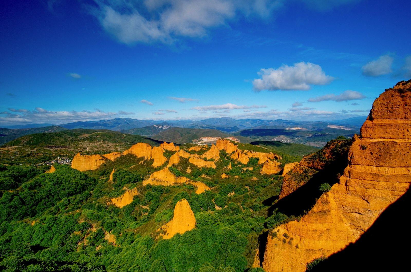
From Ponferrada to A Rúa. The first stage is the toughest of the start: 760 m of climbing to reach Las Médulas, passing by Cornatel castle. Then the path drops to the Sil at Puente de Domingo Flórez, enters Galicia and crosses the vineyards of Valdeorras, with a short, flat stage to A Rúa. See the stage Ponferrada › Las Médulas.
Ribeira Sacra and Monforte: 4 stages and 94.6 km
The most beautiful section of the Camino de Invierno, and also the hardest. From A Rúa to Quiroga the path climbs and drops along the slopes of the Sil, with a steep descent towards Albaredos; from Quiroga to A Pobra do Brollón there are 747 m to climb. Monforte de Lemos, just 12.5 km from A Pobra, deserves a free afternoon. The stage from Monforte to Chantada, 30.4 km, is the longest of the route and drops to the Miño among terraced vineyards. See the stage A Rúa › Quiroga.
Chantada and the Deza: 3 stages and 63.0 km
Leaving Chantada the longest climb begins: 705 m up to the chapel of Nosa Señora do Faro, at 1,110 m, the highest point of the route, with wide views. Then the terrain eases through Rodeiro, Lalín and Silleda, cattle country known for cocido and empanada. See the stage Chantada › Rodeiro.
Finish along the Vía de la Plata: 2 stages and 40.6 km
At Silleda the Camino de Invierno joins the Vía de la Plata and the Camino Sanabrés, and shares the last 40.6 km with them: the Ulla valley at Ponte Ulla, Outeiro and the arrival in Santiago through the Sar district. See the stage Silleda › Outeiro.
The Camino de Invierno stage by stage
A summary of each stage of the Camino de Invierno: distance, climbing, villages on the way and where there is accommodation. Each stage page has the map, the profile and all the services.
Stage 1: Ponferrada › Las Médulas. 27.8 km and about 800 m of climbing; moderate. It passes through Toral de Merayo, Villalibre de la Jurisdicción, Priaranza del Bierzo, Santalla del Bierzo, Villavieja and Borrenes. Before the end there is accommodation in Priaranza del Bierzo (1), Santalla del Bierzo (1), Villavieja (1) and Borrenes (3), in case you want to shorten it. See the stage.
Stage 2: Las Médulas › O Barco de Valdeorras. 27.2 km and about 350 m of climbing; moderate. It passes through Puente de Domingo Flórez, Quereño, Pumares, Sobradelo and Éntoma. Before the end there is accommodation in Puente de Domingo Flórez (3) and Sobradelo (3), in case you want to shorten it. See the stage.
Stage 3: O Barco de Valdeorras › A Rúa. 12.9 km and about 120 m of climbing; easy. It passes through Arcos and Vilamartín de Valdeorras. Before the end there is accommodation in Arcos (1) and Vilamartín de Valdeorras (3), in case you want to shorten it. See the stage.
Stage 4: A Rúa › Quiroga. 28.2 km and about 650 m of climbing; moderate. It passes through Albaredos, Montefurado, O Ermidón, Bendilló, Soldón and Os Novais. Before the end there is accommodation in Montefurado (1) and Soldón (1), in case you want to shorten it. See the stage.
Stage 5: Quiroga › A Pobra do Brollón. 23.5 km and about 630 m of climbing; moderate. It passes through Ribas de Sil, Carballo de Lor, A Ponte and Castroncelos. Before the end there is accommodation in Ribas de Sil (1), in case you want to shorten it. See the stage.
Stage 6: A Pobra do Brollón › Monforte de Lemos. 12.5 km and about 90 m of climbing; easy. It passes through Cereixa and Reigada. See the stage.
Stage 7: Monforte de Lemos › Chantada. 30.4 km and about 760 m of climbing; hard. It passes through A Corga, Regueiro, A Broza, Piñeiro, O Camiño Grande and Vendanova. Before the end there is accommodation in Piñeiro (1), Diomondi (1), Belesar (2) and A Devesa (1), in case you want to shorten it. See the stage.
Stage 8: Chantada › Rodeiro. 25.4 km and about 690 m of climbing; moderate. It passes through Centulle, A Lucenza, Penasillás, Vilanova de Camba, A Ermida de Camba and A Feira. See the stage.
Stage 9: Rodeiro › Lalín. 21.9 km and about 370 m of climbing; easy. It passes through Penerbosa, A Penela, A Eirexe de Pedroso, A Ponte de Pedroso and Palmaz. See the stage.
Stage 10: Lalín › Silleda. 15.7 km and about 260 m of climbing; easy. It passes through Bergazos, A Laxe and Trasfontao. Before the end there is accommodation in Bergazos (3), A Laxe (1) and Trasfontao (2), in case you want to shorten it. See the stage.
Stage 11: Silleda › Outeiro. 23.9 km and about 390 m of climbing; easy. It passes through Bandeira, Dornelas, San Miguel de Castro and Ponte Ulla. Before the end there is accommodation in Bandeira (3), Dornelas (1), San Miguel de Castro (2) and Ponte Ulla (3), in case you want to shorten it. See the stage.
Stage 12: Outeiro › Santiago de Compostela. 16.7 km and about 360 m of climbing; easy. It passes through Lestedo, A Susana and Piñeiro. Before the end there is accommodation in Lestedo (1) and Piñeiro (1), in case you want to shorten it. See the stage.
Why it is called the Camino de Invierno
From Ponferrada, the Camino Francés climbs to O Cebreiro, at about 1,300 m, a pass that is often covered in snow in winter. That is why, in the cold months, pilgrims and muleteers took this other, lower way into Galicia along the course of the Sil, the old natural route between the Meseta and inland Galicia, already used in Roman times, when the gold of Las Médulas was mined.
For centuries it was a forgotten route. The associations of Friends of the Camino and the towns along the way worked to recover it, and the Xunta de Galicia recognised it as an official Way of St James in 2016. Its highest point is at 1,110 m, in the Sierra del Faro, lower than O Cebreiro, although the climbs of the Ribeira Sacra make it harder than its name suggests.
Must-sees on the Camino de Invierno
The places worth a stop, in the order they appear on the Camino de Invierno.
- Templar Castle · Ponferrada (stage 1). A 12th to 15th-century fortress and National Monument; most of what you see today was built later by the Counts of Lemos.
- Cornatel Castle · Villavieja (stage 1). A fortress on a rocky outcrop, from the 9th to the 16th century, with free entry and its own pilgrim stamp (closed Mondays and Tuesdays).
- Las Médulas · Las Médulas (stage 1). The remains of a huge Roman gold mine, reddish earth mounds among chestnut trees, a World Heritage Site as a cultural landscape.
- Vilamartín wine cellars · Vilamartín de Valdeorras (stage 3). More than 200 cellars dug into old gold-mine galleries; on the first Saturday of August about fifty open for tastings.
- Monte de San Vicente do Pino · Monforte de Lemos (stage 6). The 16th-century monastery, now a Parador, and the 30 m keep, the largest surviving in Galicia, with a museum and views over the valley.
- Chapel of Nosa Señora do Faro · Sierra del Faro (stage 8). The highest point of the route, at 1,110 m, with views over the Ribeira Sacra and the Deza.
When to walk the Camino de Invierno
As its name says, it is a route you can walk in winter: of its 25 albergues, 20 are still open in January. Even so, the best seasons are spring and autumn. In summer the Sil valley is very hot, with average highs of 28.4 °C in August. The month with the most pilgrims is May, with 516 arrivals in Santiago in 2025.
| Month | Avg. high | Avg. low | Albergues open | Pilgrims 2025 |
|---|---|---|---|---|
| January | 11.1 °C | 2.9 °C | 80 % | 56 |
| February | 13.4 °C | 3.1 °C | 80 % | 41 |
| March | 16.8 °C | 4.8 °C | 80 % | 90 |
| April | 18.0 °C | 6.3 °C | 96 % | 197 |
| May | 21.1 °C | 9.0 °C | 96 % | 516 |
| June | 25.6 °C | 12.2 °C | 96 % | 373 |
| July | 28.2 °C | 14.1 °C | 96 % | 474 |
| August | 28.4 °C | 13.9 °C | 96 % | 231 |
| September | 25.3 °C | 11.9 °C | 96 % | 313 |
| October | 19.7 °C | 9.2 °C | 96 % | 246 |
| November | 14.3 °C | 5.9 °C | 84 % | 164 |
| December | 11.3 °C | 3.7 °C | 80 % | 57 |
How to get to Ponferrada
Ponferrada has a direct train from Madrid, of about 4 h 18 min, and good road links with León and Galicia. If you only want the last 100 km for the Compostela, you can start in Chantada; Monforte de Lemos, with a train station, is another good starting point to walk the Galician half. When you finish in Santiago, getting back is easy by train, bus or plane.
Where to sleep on the Camino de Invierno
There are 25 albergues before Silleda, 9 of them public, and a bed costs €18.30 on average: sleeping in albergues for the 10 stages to Silleda comes to about €183. Small villages have few beds, so in spring and autumn it is worth booking. Each stage lists the accommodation with price, beds and phone number, and in the accommodation finder you can filter by town.
What to eat on the Camino de Invierno
- El Bierzo: botillo, roasted peppers and D.O. Bierzo wine.
- Valdeorras: D.O. Valdeorras wine, above all godello, and the traditional cellars of Vilamartín.
- Monforte de Lemos: tapas and wine in the bars of the centre, with the Ribeira Sacra in your glass.
- Chantada: the Wine Fair in March and the Martes da Empanada festival in August.
- Rodeiro: the bakery that every week supplies bread to the Spanish Royal Household.
- Lalín: the Feira do Cocido, one of the great cocidos of Galicia.
Tips for the Camino de Invierno
- Carry water and some food: there is a 20.1 km stretch with no fountain, bar or shop.
- Train for the descents: the Ribeira Sacra has steep slopes that punish the knees; poles help.
- Take the Ribeira Sacra calmly: Quiroga and Monforte are good stops, and the Monforte › Chantada stage can be split.
- In winter, check first which albergues are open and carry rain gear: the Sil valley is damp and foggy.
- If you want your backpack carried, ask in advance: Correos only does it on request and Monday to Friday.
Credential and Compostela
To sleep in the albergues you need the credencial, which you can get from parishes, Friends of the Camino associations and authorised albergues; in 2026, for the tenth anniversary, the Peregrinus Dezae association of Lalín has issued its own Camino de Invierno credencial.
You ask for the Compostela on arrival at the Pilgrim Office in Santiago. You must have walked at least the last 100 km: on this route, the shortest start is Chantada. Get your credencial stamped twice a day over the last 100 km.
Camino de Invierno FAQ
How many kilometres is the Camino de Invierno?
266.1 km from Ponferrada to Santiago in 12 stages: 225.5 km to Silleda and another 40.6 km shared with the Vía de la Plata.
Where does the Camino de Invierno start?
In Ponferrada, in El Bierzo, where it leaves the Camino Francés to enter Galicia along the Sil valley.
Why is it called the Camino de Invierno?
Because it avoided the O Cebreiro pass, which used to be snowed up in winter: following the Sil, the way into Galicia is lower.
Which is the hardest stage of the Camino de Invierno?
The one from Monforte de Lemos to Chantada, 30.4 km, and the one from Chantada to Rodeiro, with 705 m of climbing to the highest point, at 1,110 m.
Where do you need to start to get the Compostela?
From Chantada, 104 km from Santiago, the shortest start that meets the 100 km.
Can you walk the Camino de Invierno in winter?
Yes: 20 of its 25 albergues are open in January. Carry rain gear and phone ahead to the albergues in small villages.
How many albergues are there on the Camino de Invierno?
25 before Silleda, 9 of them public, with an average bed price of €18.30.
How many days does it take to walk the Camino de Invierno?
About 12 days on foot. With the planner you can spread it over the days you have.
Plan your days with the planner. If you are looking for another way into Galicia, compare it with the Camino Francés or with the Camino Sanabrés, and to prepare the trip see the practical guides to the Camino de Santiago or compare routes in all the Caminos.