
Camino de Madrid
The Camino de Madrid leaves the capital, crosses the Sierra de Guadarrama on the Roman road of La Fuenfría and crosses the Castilian Meseta through Segovia, Coca and Tierra de Campos to Sahagún, where it joins the Camino Francés. It covers 323.2 km in 13 stages to Sahagún and 682.7 km to Santiago.
It is a quiet route, with few pilgrims, albergues that are almost always municipal and a huge heritage: the Segovia aqueduct, the castles of Manzanares el Real and Coca, Simancas and Medina de Rioseco. In this guide you have the key facts, the map, the stages, the must-sees, when to go, where to sleep, what to eat and how to continue to Santiago.
- The stages
- Key facts
- Stages by section
- Stage by stage
- Must-sees
- When to go
- From Sahagún to Santiago
- Where to sleep
- What to eat
- Tips
- Credential and Compostela
- FAQ
The stages of the Camino de Madrid
The map shows the whole route and below it each stage with its start, finish and distance. Tap one to see its elevation profile, the villages along the way and where to sleep.
Tap a point to see the stage; zoom in to see the numbers. On mobile, tap the map to move it. Route: © OpenStreetMap contributors (ODbL).
Easy Moderate Hard
The stages from Alcazarén to Sahagún, through Puente Duero, Peñaflor de Hornija, Medina de Rioseco, Cuenca de Campos and Santervás de Campos, are in the following table, each with its detailed page.
| Stage | From › to | Km | Ascent (m) |
|---|---|---|---|
| 8 | Alcazarén › Puente Duero | 24.9 | 57 |
| 9 | Puente Duero › Peñaflor de Hornija | 27.4 | 318 |
| 10 | Peñaflor de Hornija › Medina de Rioseco | 24.3 | 87 |
| 11 | Medina de Rioseco › Cuenca de Campos | 25.3 | 85 |
| 12 | Cuenca de Campos › Santervás de Campos | 21.6 | 63 |
| 13 | Santervás de Campos › Sahagún | 19.2 | 82 |
Camino de Madrid key facts
| Fact | Camino de Madrid |
|---|---|
| Route | Madrid › Sahagún (323.2 km in 13 stages) |
| To Santiago | 682.7 km, continuing from Sahagún along the Camino Francés |
| Average per stage | 24.9 km |
| Total ascent | About 3,009 m to Sahagún |
| Highest point | 1,796 m, at the Fuenfría pass |
| Albergues | 34 (20 public); 26 open all year |
| Albergue bed | €15.90 on average |
| Asphalt or paved | 26% of the route |
| Longest section without a fountain, bar or shop | 26.0 km |
| Backpack transfer with Correos | Not available on this route |
The stages of the Camino de Madrid by section
The Camino de Madrid has only one mountain section, the crossing of the Guadarrama; the rest is Meseta, with long, flat stages between pine woods, cereal fields and adobe villages.
Community of Madrid: 3 stages and 70.9 km
From the church of Santiago, in the centre of Madrid, to Tres Cantos, Colmenar Viejo, Manzanares el Real, with its castle of the Mendoza family, and Cercedilla, at the foot of the sierra. See the stage Tres Cantos › Manzanares el Real.
The sierra and Segovia: 2 stages and 63.4 km
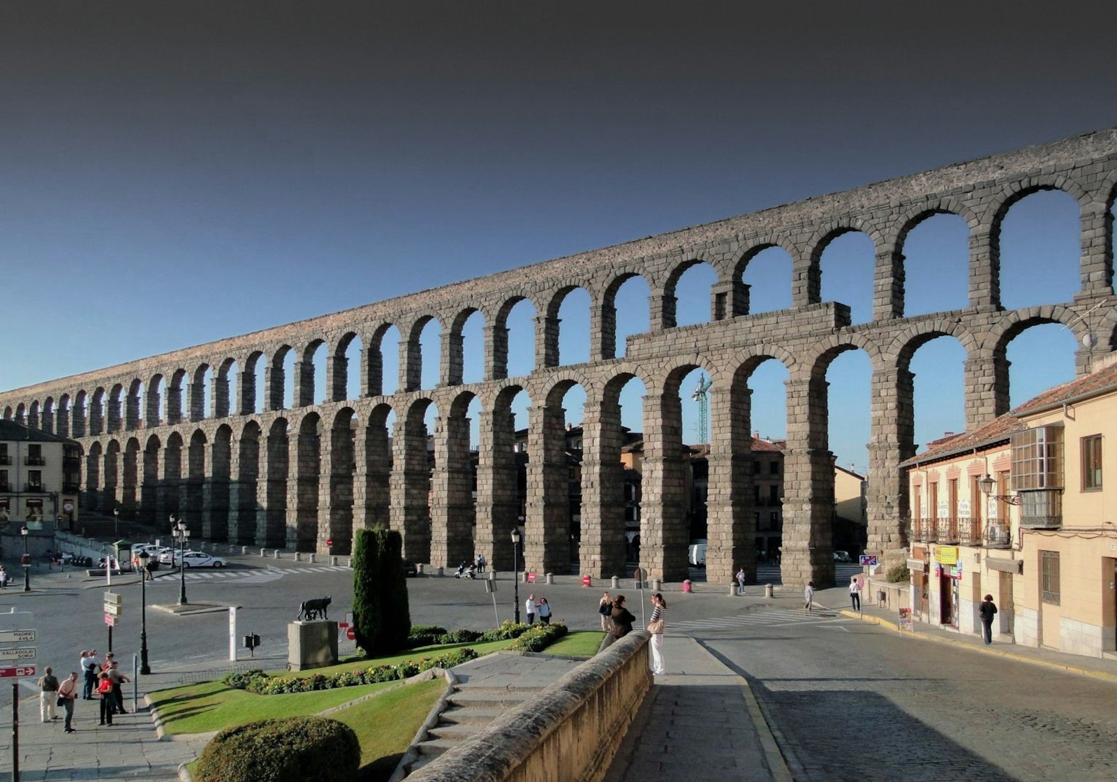
The stage from Cercedilla to Segovia, 30.2 km, is the hardest and the most beautiful: it climbs the Roman road to the Fuenfría pass, at 1,796 m, and descends through the pine forests of Valsaín and La Granja to the aqueduct. After that, the Meseta begins at Santa María la Real de Nieva. See the stage Cercedilla › Segovia.
Lands of Valladolid and Tierra de Campos: 8 stages and 188.9 km
Coca and its castle, Alcazarén, Puente Duero next to Valladolid, Simancas, Medina de Rioseco and the mud-built villages of Tierra de Campos as far as Sahagún. These are stages of 19 to 27 km, flat and with long stretches without services. See the stage Santa María la Real de Nieva › Coca.
The Camino de Madrid stage by stage
A summary of each stage of the Camino de Madrid: distance, climbing, villages on the way and where there is accommodation. Each stage page has the map, the profile and all the services.
Stage 1: Madrid › Tres Cantos. 25.2 km and about 300 m of climbing; easy. It passes through Fuencarral. Before the end there is accommodation in Fuencarral (5), in case you want to shorten it. See the stage.
Stage 2: Tres Cantos › Manzanares el Real. 25.3 km and about 450 m of climbing; easy. It passes through Colmenar Viejo. Before the end there is accommodation in Colmenar Viejo (2), in case you want to shorten it. See the stage.
Stage 3: Manzanares el Real › Cercedilla. 20.4 km and about 520 m of climbing; easy. It passes through Mataelpino and Navacerrada. Before the end there is accommodation in Mataelpino (2) and Navacerrada (7), in case you want to shorten it. See the stage.
Stage 4: Cercedilla › Segovia. 30.2 km and about 720 m of climbing; hard. It passes over the Fuenfría pass. See the stage.
Stage 5: Segovia › Santa María la Real de Nieva. 33.2 km and about 300 m of climbing; moderate. It passes through Zamarramala, Valseca, Los Huertos, Añe and Pinilla-Ambroz. Before the end there is accommodation in Zamarramala (1), Los Huertos (1) and Añe (1), in case you want to shorten it. See the stage.
Stage 6: Santa María la Real de Nieva › Coca. 22.2 km and only 16 m of climbing; easy. It passes through Nieva and Nava de la Asunción. Before the end there is accommodation in Nava de la Asunción (3), in case you want to shorten it. See the stage.
Stage 7: Coca › Alcazarén. 24 km and about 70 m of climbing; easy. It passes through Villeguillo. Before the end there is accommodation in Villeguillo (1), in case you want to shorten it. See the stage.
The last six stages, from Alcazarén to Sahagún, in summary. Each one also has its full page, linked in the stages table:
Stage 8: Alcazarén › Puente Duero. 24.9 km and 57 m of climbing, with the highest point at 738 m; easy. It passes through Valdestillas. 20% is on asphalt or paving. Carry water: there are 15.0 km in a row without a fountain, bar or shop. The longest stretch without anywhere to sleep is 15.9 km.
Stage 9: Puente Duero › Peñaflor de Hornija. 27.4 km and 318 m of climbing, with the highest point at 845 m; moderate. It passes through Simancas, Ciguñuela and Wamba. 18% is on asphalt or paving. Water and bars are well spread out: the longest stretch without services is 7.2 km. The longest stretch without anywhere to sleep is 14.7 km.
Stage 10: Peñaflor de Hornija › Medina de Rioseco. 24.3 km and 87 m of climbing, with the highest point at 846 m; easy. It passes through Castromonte and Valverde de Campos. 40% is on asphalt or paving. Water and bars are well spread out: the longest stretch without services is 8.4 km. The longest stretch without anywhere to sleep is 15.3 km.
Stage 11: Medina de Rioseco › Cuenca de Campos. 25.3 km and 85 m of climbing, with the highest point at 780 m; easy. It passes through Tamariz de Campos and Moral de la Reina. 35% is on asphalt or paving. Carry water: there are 11.2 km in a row without a fountain, bar or shop. The longest stretch without anywhere to sleep is 13.3 km.
Stage 12: Cuenca de Campos › Santervás de Campos. 21.6 km and 63 m of climbing, with the highest point at 828 m; easy. It passes through Villalón de Campos and Fontihoyuelo. 13% is on asphalt or paving. Carry water: there are 14.1 km in a row without a fountain, bar or shop. The longest stretch without anywhere to sleep is 16.2 km.
Stage 13: Santervás de Campos › Sahagún. 19.2 km and 82 m of climbing, with the highest point at 842 m; very easy. It passes through Arenillas de Valderaduey and Grajal de Campos. 26% is on asphalt or paving. Water and bars are well spread out: the longest stretch without services is 7.1 km. The longest stretch without anywhere to sleep is 13.6 km.
Must-sees on the Camino de Madrid
The places worth stopping for, in the order they appear on the route.
- Habsburg Madrid · Madrid (stage 1). Next to the start of the route, the Royal Palace, the Almudena, Plaza de Oriente and Plaza Mayor, and the great museums.
- Basilica of the Assumption · Colmenar Viejo (stage 2). 15th-century Gothic, begun under the direction of Juan Guas, with a magnificent Plateresque altarpiece from 1560-1583.
- Castle of the Mendoza family · Manzanares el Real (stage 2). A jewel of 15th-century Castilian architecture, a fortress turned into a palace.
- Roman road of La Fuenfría · Fuenfría pass (stage 4). A listed heritage site, crossed for centuries by Roman legions, shepherds and merchants and, until the mid-20th century, by thousands of Galician day labourers who came every summer to reap the wheat in Castile; hence names such as the Cruz de la Gallega.
- Aqueduct, Alcázar and cathedral · Segovia (stage 4). The Roman aqueduct, the Alcázar and the cathedral, considered the last Gothic cathedral in Spain, with a discount and its own stamp for those arriving with the credencial; and nineteen Romanesque churches, such as San Martín.
- Monastery of La Soterraña · Santa María la Real de Nieva (stage 5). The town was founded by Catherine of Lancaster after the apparition of the Virgin of La Soterraña, which according to legend a shepherd found in 1392.
- Coca Castle · Coca (stage 6). 15th-century Gothic, with the town wall, the tower of San Nicolás and the pre-Roman stone boars.
- Church of Santiago Apóstol · Alcazarén (stage 7). The village name comes from the Arabic al-qasrayn, "the two fortresses": it began in the emirate period as a fortified farmstead next to a road heading north, and its coat of arms shows two towers and an Arab key.
- Simancas Castle · Simancas (stage 9). From the 15th century; since Philip II it has housed the General Archive of Simancas.
When to walk the Camino de Madrid
It is a route with a continental climate: cold winters, with average lows close to 0 °C from December to February and possible snow at La Fuenfría, and hot summers, with average highs of 29.8 °C in July. The best seasons are spring and autumn, May to June and September to October. Most albergues are open all year.
| Month | Avg. high | Avg. low | Albergues open |
|---|---|---|---|
| January | 8.0 °C | 0.1 °C | 76 % |
| February | 10.6 °C | 0.8 °C | 76 % |
| March | 14.4 °C | 2.8 °C | 79 % |
| April | 15.9 °C | 4.2 °C | 91 % |
| May | 20.0 °C | 7.7 °C | 94 % |
| June | 26.0 °C | 11.6 °C | 94 % |
| July | 29.8 °C | 14.1 °C | 94 % |
| August | 29.3 °C | 14.2 °C | 94 % |
| September | 24.6 °C | 11.4 °C | 94 % |
| October | 18.1 °C | 7.6 °C | 91 % |
| November | 12.0 °C | 3.4 °C | 79 % |
| December | 8.6 °C | 1.1 °C | 74 % |
From Sahagún to Santiago along the Camino Francés
At Sahagún the Camino de Madrid joins the Camino Francés, and from there 359.5 km remain to Santiago, through León, Astorga, O Cebreiro and Sarria. If you want to go home from Sahagún, there is a direct train to Madrid in about 3 h 59 min.
Where to sleep on the Camino de Madrid
There are 34 albergues before Sahagún, 20 of them public, and a bed costs €15.90 on average: sleeping in albergues for the 13 stages comes to about €210. Many are municipal: out of season, phone ahead to find out whether they are open and where to collect the key. Each stage lists the accommodation with price, beds and phone number, and in the accommodation finder you can filter them by town.
What to eat on the Camino de Madrid
- To start with, traditional Madrid cooking: cocido madrileño, callos a la madrileña, garlic soup or gallinejas.
- In the Alto Manzanares district, roast suckling lamb, grilled grass-fed veal and kid stew.
- In Coca, roasts, Iberian cured meats, morcilla de calducho with pine nuts, crayfish from the Voltoya and sweets such as empiñonados, tortas de chicharrón and rosquillas de palo.
- Villalón de Campos gives its name to Villalón or pata de mulo cheese, a soft sheep's cheese.
Tips for the Camino de Madrid
- Carry water and food: the longest stretch without a fountain, bar or shop is 26.0 km.
- Check the forecast before crossing La Fuenfría: in winter there may be snow and ice.
- Phone the municipal albergues ahead to find out where to collect the key.
- Leaving Madrid there are many urban kilometres: you can start in Tres Cantos or Colmenar Viejo.
- There is no Correos backpack transport: carry only the essentials.
Credential and Compostela
You can get the credencial from, among other places, parishes and Friends of the Camino associations; it gives access to the albergues and is the proof you need to request the Compostela.
For the Compostela you must walk at least the last 100 km to Santiago: walking only the Camino de Madrid to Sahagún does not earn it, you have to continue along the Camino Francés at least from Sarria. The Compostela is collected free of charge at the Pilgrim Office in Santiago.
Camino de Madrid FAQ
How many kilometres is the Camino de Madrid?
323.2 km from Madrid to Sahagún in 13 stages, and 682.7 km to Santiago continuing along the Camino Francés.
Where does the Camino de Madrid start?
At the church of Santiago, in the centre of Madrid, and it leaves the city towards Tres Cantos.
Which is the hardest stage of the Camino de Madrid?
The one from Cercedilla to Segovia: 30.2 km crossing the Guadarrama over the Fuenfría pass, at 1,796 m.
How many days does it take to walk the Camino de Madrid?
About 13 days to Sahagún and another 15 or 16 to Santiago along the Camino Francés. With the planner you can spread it over the days you have.
What is the best time of year to walk the Camino de Madrid?
Spring and autumn. In summer it is very hot on the Meseta and in winter it can snow in the sierra.
How many albergues are there on the Camino de Madrid?
34 before Sahagún, 20 of them public, almost always municipal. 26 are open all year: in January 26 of the 32 that open in summer are still open.
How much does it cost to sleep on the Camino de Madrid?
A dormitory bed costs €15.90 on average, so the 13 nights to Sahagún come to about €207 in albergues.
Is there much asphalt on the Camino de Madrid?
Not much: around 26% of the route is on asphalt or paving; the rest is dirt tracks, drove roads and paths. The real issue is another one: there is a 26 km stretch without a fountain, bar or shop, so always set out with water.
How do you get back from Sahagún to Madrid?
By train: there is a direct train between Sahagún and Madrid, of about four hours. It is useful if you walk the Camino de Madrid in sections and do not continue to Santiago.
Does the Camino de Madrid earn the Compostela?
Only if you continue to Santiago: you must walk the last 100 km, so from Sahagún you have to continue along the Camino Francés.
Plan your days with the planner and continue to Santiago along the Camino Francés. To prepare the trip see the practical guides to the Camino de Santiago or compare routes in all the Caminos.